|
Railfan Adventures |
|
Adventure Trips |
|
Mexican Adventures |
|
American Graffiti |
|
|
|
Railfan Adventures |
|
Adventure Trips |
|
Mexican Adventures |
|
American Graffiti |
|
|
|
|
|
|
|
Back in 1997, a co-worker of mine, who has a lot of connections and rudimentary medical skills, took a trip to Bahia Tortugas with the Flying Doctors, for a long weekend of helping out at the only clinic in town. According to Laurie, the clinic was poorly stocked, and their expertise was somewhat limited, so she and the team she traveled with really made a difference, as Bahia Tortugas receives few visitors. She and the doctors flew into the town, and landed on the dirt landing strip, and hiked the few short blocks into the town proper. She described the town as ramshackle, poorly organized, and not at all a tourist destination, as the town has no tourist facilities, and receives few visitors, except for members of the yacht crowd who mostly stop for fuel and supplies. At that point in time, I made up my mind to visit Bahia Tortugas.
Photo: This sign marks the turnoff from Highway 1, at the small town of Vizcaíno, to Bahia Tortugas, via Highway 1. Confusing, at best... I had to clarify things by asking the guy at the gas station. During my travels to Baja California, I've visited some very out-of-the way destinations, but Bahia Tortugas has them all beat, as it's probably the most isolated town (as opposed to a rancho or a fishing village) on the Baja peninsula. There are three ways to get to Bahia Tortugas: By air, as my friend Laurie did, but sea,, where you take your chances climbing up the rickety ladders to the municipal pier, or the 110 mile sometimes paved road, that takes off from Baja Highway 1 at Vizcaíno, which is about an hour south of Guerro Negro, Baja California Sur. I don't fly, and I don't have the money for a yacht, so I chose to drive this interesting road, across the Vizcaíno Desert to Bahia Tortugas.
Photo: After you're headed west for a half mile or so, this broken-down sign confirms that you're headed in the right direction. If you're contemplating to Bahia Tortugas, you've probably heard all kinds of horror stories about terrible condition of the road, and how four wheel drive is required, and how remote the country is. Sure, I drove my very capable four wheel drive truck, but the only reason I drove my truck was that I planned to go home via the notoriously-bad road that heads up the east side of the peninsula to San Felipe. The extreme east and west ends of the road to Bahia Tortugas are paved, but the majority of the road is a typical Mexican government dirt and sometimes gravel road, that's notoriously washboarded, and follows the contour of the land. There are absolutely no services of any kind available between Vizcaíno and Bahia Tortugas, so when you venture off the highway, be sure to fill 'er up, and grab whatever supplies you require.
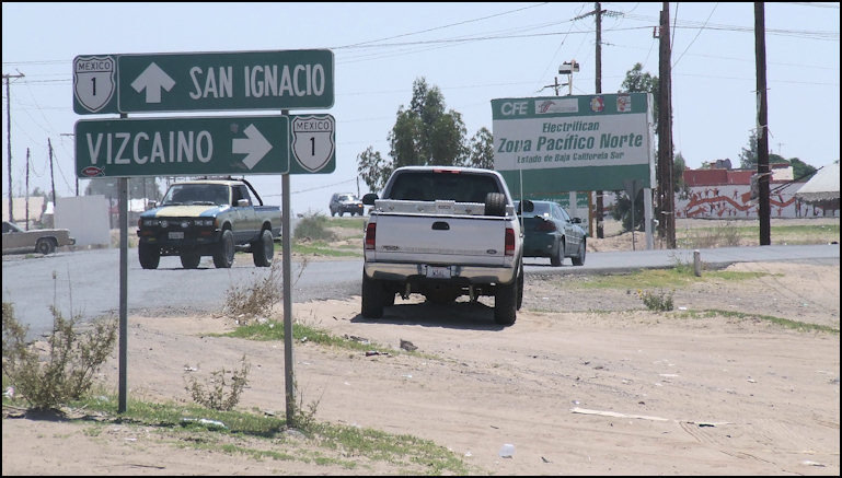
Photo: When you're traveling the highways of Mexico, you must always watch for livestock, as most land is open range land. It was kind of him to pose by the km post, so I could remember exactly where he was, when I wrote this article three months after the encounter. The road to Bahia Tortugas leaves Mexico Highway 1 at the small community of Vizcaíno, which offers gas, food, motels, groceries, Internet access, and just about anything else you might need. I've read various reports that the personnel at the Pemex station will rig the gas pumps so they overcharge unsuspecting gringos, but I gassed up at the station and had no problems, as the personnel were honest and courteous. The turnoff the Bahia Tortugas is marked by a highway sign that simple reads "Vizcaino," which seemed odd to me, so I asked the gas station attendant if this was indeed the road to Bahia Tortugas, and he replied that it was. Curiously, the sign also has a Federal Highway shield on it, yet it's not the highway... go figure. If you have a GPS, the coordinates at this junction are N 27.39.000, W 113.23.174, and the elevation is 258 feet. At this point, the road is paved, and in reasonably good shape.
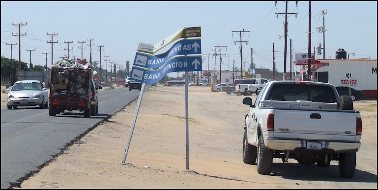
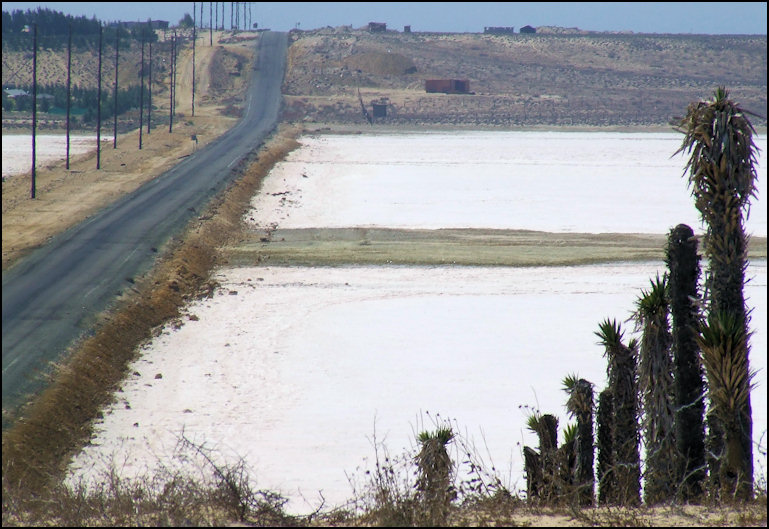
Photo: The paved road skirts a salt flat, and views of Scammon's Lagoon can be seen to the north. As I drove through the town, I noticed a broken down sign that clearly pointed me in the direction of Bahia Tortugas, and the turnoff to Bahia Asunción. Like most highways in Baja California, the pavement is quite narrow, with little, if any shoulder, and the streets of the town of Vizcaíno are dirt.
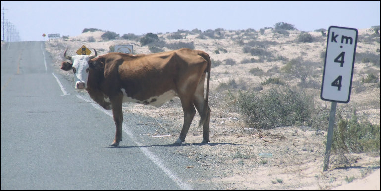
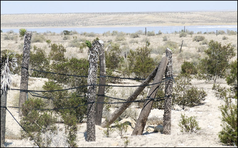
Photo: Looking across the desert to an arm of Scammon's Lagoon. Note the Joshua Trees are being used as fence posts; the locals are quite clever at utilizing the materials at hand for their needs. From Vizcaíno, the road heads almost due west, across the flat, Vizcaíno Desert. Soon, you have the small town of Vizcaíno, and nearby Ejido Gustavo Díaz Ordaz in your rear view mirror, and the country is just rolling desert, with a house here and there, and open range land. Just before encountering the fill where the road hugs the salt lagoon, I encountered a couple of cows on the road, so drive with care. Today, Friday, September 26, 2008, paved road was in good condition, and it follows the lay of the land, across the rolling, sandy hills of the Vizcaíno Desert.
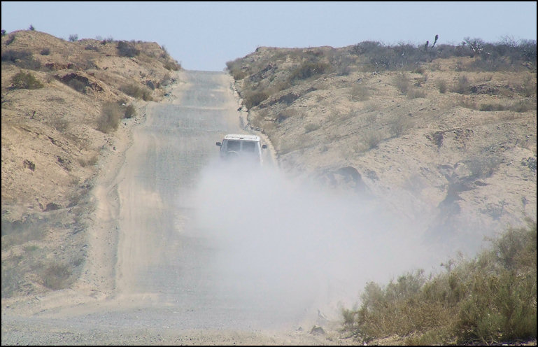
Photo: Here's a good example of the dust encountered when you're passed. In my case, I was parked by the side of the road when I was passed by this van. I let the dust settle for a few minutes before continuing the drive to Bahia Tortugas. Fortunately, few other vehicles are encountered. The drive to the junction to Bahia Asunción isn't particularly scenic or interesting, as the desert is quite flat, and has very little vegetation. Off to the north, you can see the very blue water of Laguna Ojo de Liebre, also known as Scammon's Lagoon, which contrasts with the stark, brown desert.
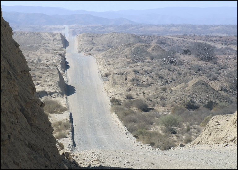
Photo: Stark desert scenery, between Vizcaíno and Bahia Tortugas The only major, paved junction that you'll encounter between Vizcaíno and Bahia Tortugas, is where a paved road heads south to Bahia Asunción. The paved road ends here, and you're about 42 miles west of Vizcaíno. GPS coordinates are N 27.25.905, W 114.04.131, and the elevation is 94 feet. For the majority of the rest of the way to Bahia Tortugas, it's a graded, gravel road, with lots of washboarding, and lots of rough spots. Get ready for over 50 miles of bone-jarring travel before coming to the pavement, encountered about 10 miles east of Bahia Tortugas.
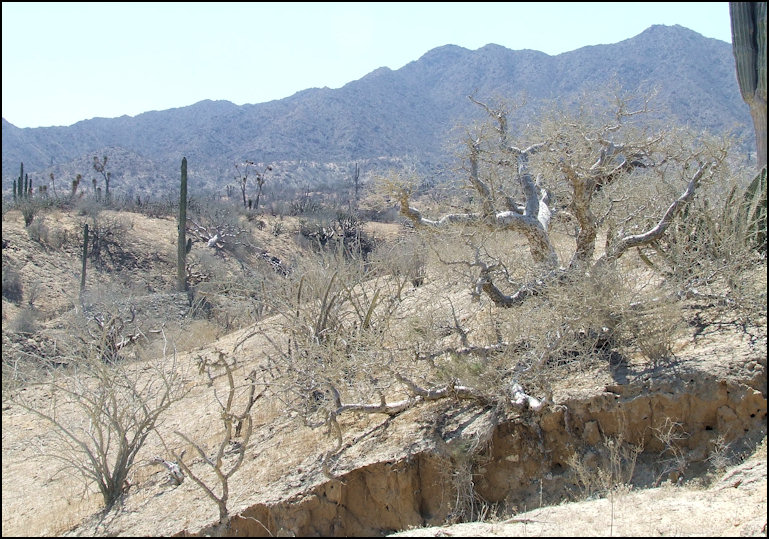
Photo: The dirt/gravel road is modestly engineered, as it heads west through the desert, toward Bahia Tortugas. You're traveling through the Vizcaíno Desert, which is some of the most hard-core desert that you'll ever have the pleasure to see. It's a land of volcanic cinder cones, rocks, brown, dusty earth, with little vegetation, and even less rainfall. Rainfall is so scarce that what little vegetation that grows in this barren land has learned to survive by getting moisture from the coastal fog. It's a land of coyotes and buzzards, and you'll see plenty of both.
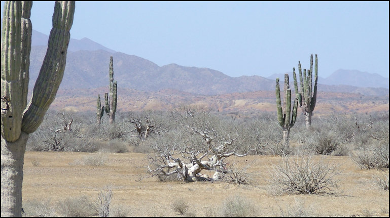
Photo: Further west, giant suguro cactus appear, and replace the boom jun and Joshua trees. West of the major junction, the drive becomes more interesting, as the country changes from flat, nearly barred desert, to rolling hills, studded with cactus. As the road heads due west, it travels through the hills, with one cut and accompanying fill after another. As the dirt and gravel road heads through the hills, its almost like a roller coaster ride, as the engineering is minimal. It's makes for a dusty, and bumpy ride, yes it's fascinating, as the scenery is nothing like I've ever seen north of the border. Secondary dirt roads and four wheel drive trails take off from either side of the main road; some are marked, pointing out the way to isolated ranches or fish camps, but most aren't. Since I was driving my well-equipped four wheel drive truck, each of these dirt roads pulled at my heart strings, but I resisted temptation, as my destination was Bahia Tortugas. I carry a detailed atlas of Baja California, which includes GPS coordinates, so its not at all difficult for me to find my way around, and I've found the atlas is quite accurate. Speaking of GPS, my moving map display does not include maps for Mexico, so I have to navigate the old fashioned way, but using latitude and longitude, and a whole lot of dead reckoning.
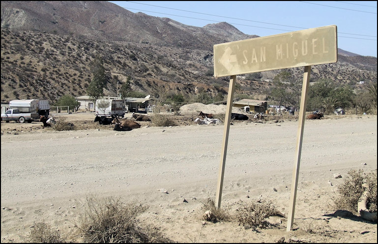
Photo: Dusty Ranch San Miguel, near the end of the dir/gravel road. This close-up photo gives you an idea of what the road is like - washboarded and very dusty. Note how the dust clings to everything, including the sign. Just when you think that you or your vehicle can't take any more dusty, bone-jarring, washboarded road, the blessed sight of pavement appears, which signals that you're about 10 miles from Bahia Tortugas. The engineering standards are practically identical to the unpaved section of the road; the only difference is that its paved, and not dusty! About the time that you round a corner in the road, and the town comes into view, there's a semi-major gravel road that takes off to your right, in a northerly direction that leads to Bahia Sebastian Vizcaíno, and a couple of interesting fish camps. Alas, I was not able to take this road to explore these places; maybe next time.
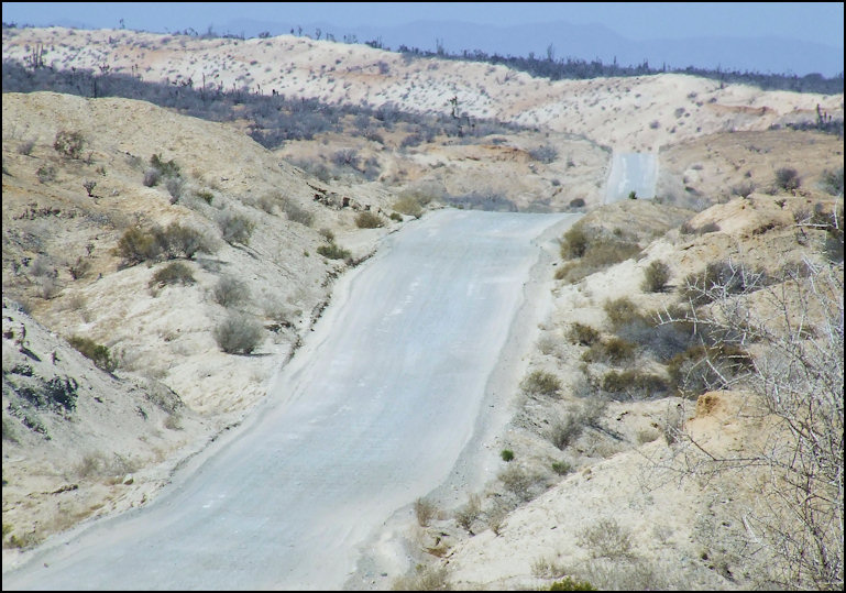
Photo: Looking west toward Bahia Tortugas. Engineered roads utilize the cut and fill method... I see plenty of cuts, but where are the fills?
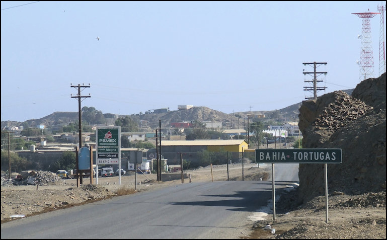
Photo: Pavement is encountered about 10 miles east of Bahia Tortugas, thank goodness! Note the engineering is practically identical to that of the dirt section, in that it follows the lay of the land, and utilizes few fills. Just before entering the town, you'll see a sign that reads "Bahia Tortugas," which is a bit of a rarity, as few towns, commonly known is Mexico as poblados sport signs that reveal their names to the uninitiated. Just past the name sign, there's a dirt road that leads up to a hill, which affords a panoramic view of the town of Bahia Tortugas, the bay of the same name, and the Pacific Ocean in the distance. It's also a spot to get your bearings of the town, keeping in mind that the prominent radio tower, with the flat-dish capacitance hat on top should be your reference point, as it's almost in the center of town. More on that in the section that I've written about the town of Bahia Tortugas.
Photo: A welcome sight - Bahia Tortugas is reached, over 100 miles from the town of Vizcaíno. The tall radio tower with the flat top is almost in the exact center of town, and it makes a good landmark to navigate by. It's about a three and a half hour, bumpy and dusty drive from Vizcaíno to Bahia Tortugas, but its an interesting drive, as you'll see scenery that exists nowhere else on earth, and you'll be treated to your end destination: Bahia Tortugas. Copyright(c) 2009 eRench Productions. All rights reserved.
|