|
|
|
|
|
|
|
Belive or not, even though I've been exploring Panamint Valley since 1993, I'd never been to Darwin Falls. Sure, I'd heard about it for years, but I'd just never got around to making the short hike to the falls. That evening, as we were eating dinner at Panamint Valley Springs, our lovely waitress, Melanie, remarked that she had visited the falls for the first time the previous weekend, and how scenic and interesting they are. I quizzed her about the difficulty of the hike, she said it was easy, so I made up my mind to take the hike to Darwin Falls the next day.
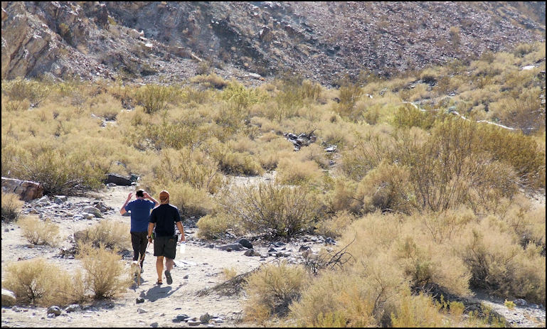
Photo: This is where the trail starts... does it look like there's a waterfall a little only a mile away? Note the pipe to the right of the photo that supplies Panamint Springs Resort with water. After breakfast, on Monday, November 10, 2008, I turned west on CA 190, and drove the short half mile to the Old Toll Road, which was the start of the Back Door To Darwin run that I made the previous Saturday, while attending Panamint Valley Days, 2008. If you're addicted to a GPS like I am, you'll find it handy to know that the GPS coordinates are N36.20.413, W117.28.828, with an elevation of 1867 feet. CalTrans has a placed a sign that reads "Darwin Falls Rd" but my GPS, and most of my maps label the road as "Old Toll Road." Whatever the name is, it's a 2.41 mile drive up the rough, washboarded, dirt road to the parking lot for the hiking trail to Darwin Falls. As rough as the road may be, if you drive slowly and carefully, it's suitable for a passenger car. Pull into the small, dirt parking lot, and you're ready to start your hike. The GPS for the parking lot is N36.19.659, W117,30.875, at elevation 2497 feet.
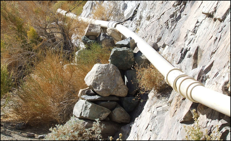
Photo: I had to laugh at the various methods used to keep the pipe in place. I suppose the ever-changing geology must make maintenance somewhat difficult... This pipe supplies water to Panamint Springs Resort, as the resort gets it's water from Darwin Falls. It's easy to find the trail, as you just head west into the canyon, on what once was a four wheel drive trail. Prior to passage of the Desert Protection Act, in 1994, you could four wheel up the canyon, almost to the falls. Now, this area is known as the Darwin Falls Wilderness, and its administered by the Park Service. Although this area is not in Death Valley National Park, nevertheless, they still call the shots. Whatever the case, this is a very unique area, and one of four waterfalls located in the park, and the falls has its own eco-system. The falls flow year around, and not only do they provide water for Panamint Springs Resort, they're the major source of water for all of the desert birds and animals. Actually, I don't have a problem with the trail closure, as its a fun hike, and the lack of vehicle traffic helps keep the area pristine.
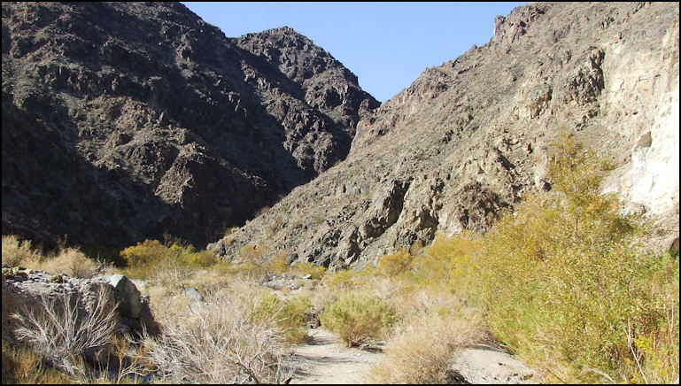
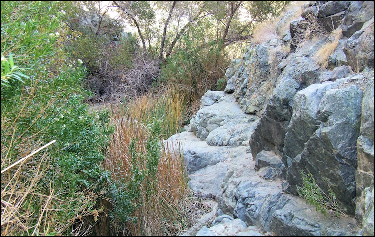
Photo: After hiking only .3 miles, willows begin to appear, but still no sign of a stream. The foot path starts out on the north side of the canyon, which is to your right. You'll notice an ugly pipe attached to the side of the canyon; that's how the water from the falls is piped into Panamint Springs Resort. As you hike west in the canyon, willows appear .3 miles from the parking lot, and in another .3 miles, the stream appears, and you can hear it rushing through the willows. .73 miles from the parking lot, serious trees appear, the willows grow very thick, the canyon narrows, and the path hugs the south side of the canyon. You sort of have to scramble over rocks, and even step in the stream in a few places. Be careful, as the rocks are very slippery in places, and you could easily slip and fall into the stream. I was glad that I wore GoreTex lined hiking boots, but I still had to be careful, as the stream is deeper than my boots are high.
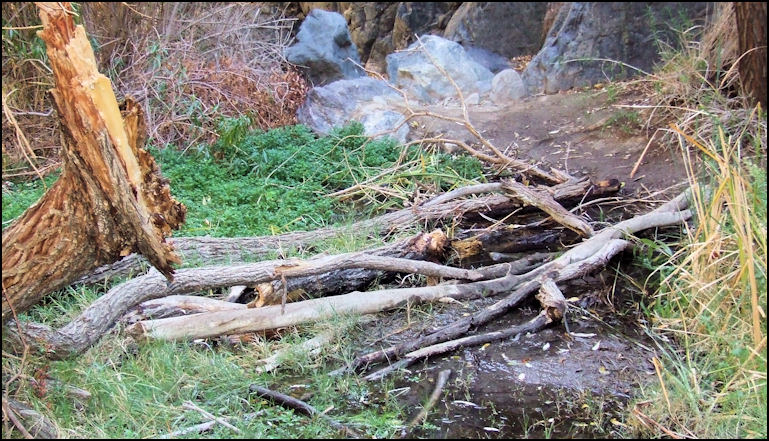
Photo: After about a mile, you'll encounter serious trees, and you'll have to ford the stream in several places. Here's a photo of one of the crossings.
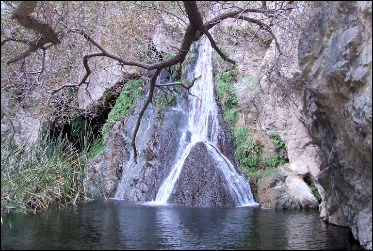
Photo: As you near the falls, you have to scramble over rocks, unless you care to splash through the stream and fight the dense vegetation... Lower Darwin Falls is only 1.37 miles from the parking lot, and the GPS coordinates are N36.19.243, W117.31.437, at an elevation of 2709 feet. You've only climbed 212 feet, in just a little over a mile, see, didn't I tell you this is an easy hike? Lower Darwin Falls is impressive, as its about 20 feet high, as it falls from the rocks. The grotto is cool and shady, and the sound of the flowing water is very pleasant. Doing my research, I've read that upper Darwin Falls is even more impressive, and I could see the trail heading up the north side of the canyon, but the trail is narrow, steep, and features some serious drop-offs. I probably would have scrambled up to the upper falls except that the "trail" was very slippery, as it was covered with moss and mud from the rain the area received from the previous day. I didn't want to do a free fall into the water, so I decided to pass. The stream that feeds Darwin Falls starts at a spring, just up from China Garden Spring, about four miles up the canyon. You CAN hike from China Garden Spring to Darwin Falls, and ultimately the parking lot, but it requires some mountaineering, including a bit of rappelling. No thanks...
Photo: Lower Darwin falls, from stream level. Due to the dense vegetation, good photos are a bit difficult, unless you care to wade in the water. On this cool November day, that wasn't an option for me.
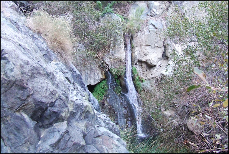
Photo: I climbed up on some rocks to get this view of the falls. The pool can be seen at the extreme bottom of the photo. I took a few photos, a couple of video clips, and refilled my canteen before heading down the canyon. When I reached the parking lot, my GPS told me that the total mileage that I hiked was 2.52 miles, and was only gone a little over 2-1/2 hours, and a good deal of the time was spent taking photos and admiring the scenery. The hike was a lot of fun, the scenery was beautiful, and the whole experience quite unique. If you didn't know it was there, nobody could guess that such a lovely waterfall exists in one the driest regions of the North American continent. A hike to Darwin Falls should be on your Panamint Valley things-to-do-list. Copyright(c) 2023 eRench Productions. All rights reserved. We've been on the web since December 22, 2002.
|